"Make no mistake. The devastation and flooding we're experiencing across Vermont is historic and catastrophic," Gov. Phil Scott said during a Tuesday morning press conference, which he had to hike out to because the roads around his home were undrivable.
"I know thousands of Vermonters have lost homes, businesses, and more," he added during the briefing. "The devastation is far-reaching."
The flooding in Vermont came as part of a storm system that inundated Connecticut and New York—where one woman was killed—on Sunday before reaching New England, the Associated Press reported. However, the unnamed system has already had a historic impact.
"Flooding in parts of Vermont have surpassed what was experienced during Tropical Storm Irene, and rivers are expected to continue rising through the night," Scott tweeted Monday. "Stay away from waterways."
"I think everyone's in shock."
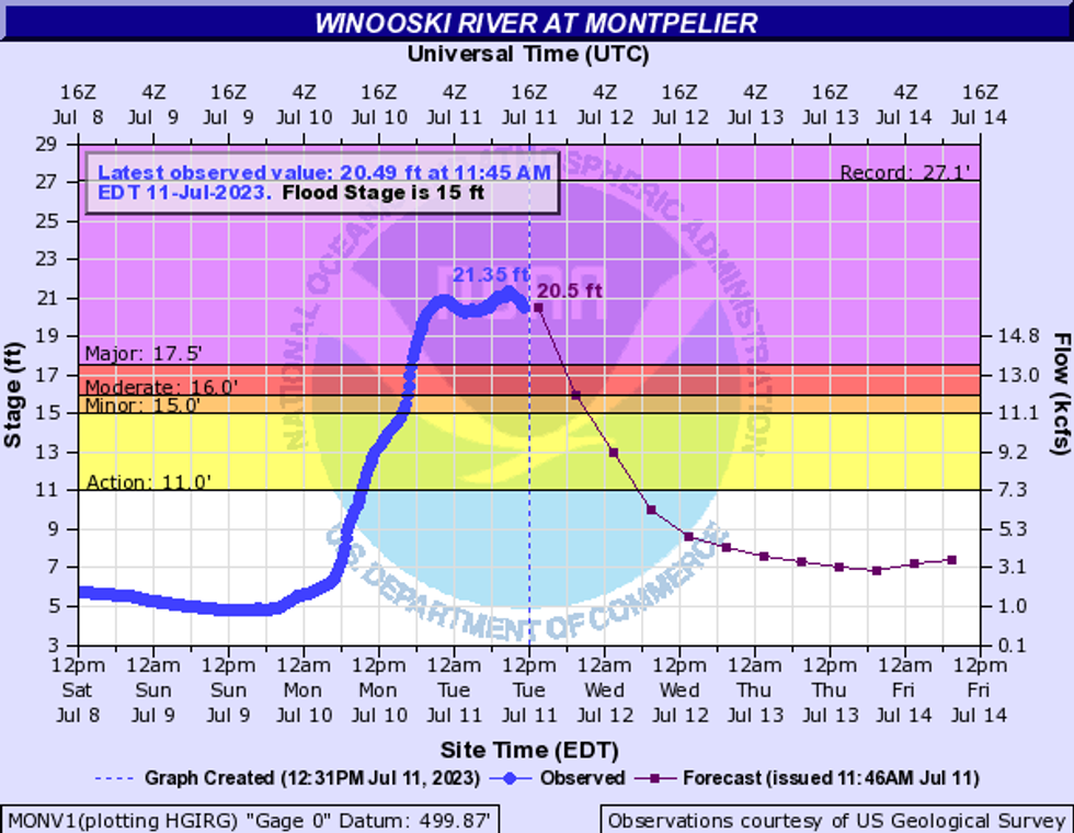
During Tropical Storm Irene in 2011, the Winooski River rose to 19 feet, at least three people died, and most of the roads in the state were damaged, The Washington Postpointed out. During the most recent storm, the Winooski at the state capital of Montpelier rose to a height of 21.35 feet Tuesday morning, according to the NWS. The only time it's ever been higher was during the Great Vermont Flood of 1927, when flooding swelled it to 27 feet and killed 84 people, the Post reported.
The Montpellier Airport set a daily rainfall record of 5.28 inches, surpassing the previous record set during Irene, as The New York Times reported.
Montpelier itself was especially hard hit, with images circulating online of its downtown underwater.
"I think everyone's in shock," Montpelier resident and Main Street gallery owner Susan Calza said, as the Times reported.
Montpilier originally closed its downtown until 12 pm ET Tuesday for safety reasons, and then extended that until 3 pm.
"Flooding is major, we can't really tell about damage yet, and there are no known casualties," city manager William Fraser told the Post in an email.
In a Facebook statement early Tuesday, Fraser warned that the Wrightsville Dam near Montpelier, Middlesex, and East Montpelier was six feet away from reaching capacity.
"This has never happened since the dam was built so there is no precedent for potential damage."
"If water exceeds capacity, the first spillway will release water into the North Branch River," Fraser said. "This has never happened since the dam was built so there is no precedent for potential damage. There would be a large amount of water coming into Montpelier which would drastically add to the existing flood damage."
The town of Ludlow in southern Vermont was also especially impacted, with flood waters cutting it off from major roads.
"The total scope of what kind of damage that has occurred in Ludlow—the onion isn't even peeled back at all right now," Ludlow Town Manager Brendan McNamara toldVermont Public Monday. "I mean, I'm up and down Main Street because that's what we can access, and it is not good."
The National Weather Service (NWS) in Burlington said late Monday that some places had seen more than nine inches of rain, which is more than is usually seen in two months, according to The Washington Post. The storm has closed at least 78 roads and prompted more than 100 swift water rescues, officials said during Tuesday's press conference. No injuries or deaths have been reported, but Department of Public Safety Commissioner Jennifer Morrison cautioned that rescues were still in progress.
"I want to reiterate that we are still in the earliest stages of this disaster," she said.
State officials are also concerned by additional rain forecast for Thursday and Friday.
"Even though the sun may shine later today and tomorrow, we expect more rain later this week which will have nowhere to go in the oversaturated ground," Scott said. "So I want to be clear—we are not out of the woods."
The Northeastern U.S. is not alone in experiencing deadly flooding this year: Serious deluges have taken place in India, China, Japan, and Turkey in 2023, The Guardian reported.
"As the climate gets warmer we expect intense rain events to become more common, it's a very robust prediction of climate models," University of Miami professor of atmospheric sciences Brian Soden told The Guardian, adding, "It's not surprising to see these events happening, it's what models have been predicting since day one."
Every 1°C increase in temperature enables the same volume of air to carry 7% more water vapor, according to a June report from the First Street Foundation. This means that one-in-100-year rainfall events are occurring as often as every five or 10 years in some parts of the U.S.
The Northeast is expected to be particularly impacted by increased precipitation, risk associate director at the Woodwell Climate Research Center Zachary Zobel toldThe Boston Globe.
"We're heading into a new normal," Zobel said. "The climate you've experienced previously is not the climate you're going to be living in for the next 30 years."
This content originally appeared on Common Dreams and was authored by Newswire Editor.
Newswire Editor | Radio Free (2023-07-11T18:18:39+00:00) Federal Court Stays Mountain Valley Pipeline’s Biological Opinion Again. Retrieved from https://www.radiofree.org/2023/07/11/federal-court-stays-mountain-valley-pipelines-biological-opinion-again/
Please log in to upload a file.
There are no updates yet.
Click the Upload button above to add an update.
