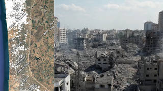
Democracy Now! speaks with two researchers who lead the Decentralized Damage Mapping Group, a network of scientists using remote sensing to analyze and map the damage and destruction in the Gaza Strip since Israel’s attacks began on October 7. Radar technology shows that Israel’s bombing campaign has left about half of all buildings in northern Gaza damaged or destroyed since October 7, with at least 56,000 buildings in Gaza damaged overall. Doctoral researcher Corey Scher explains how researchers use open data to bring consistent, transparent assessments of the rapidly expanding damage in Gaza. “We’ve all been surprised at the speed of this,” says Jamon Van Den Hoek, lead of the Conflict Ecology lab.
This content originally appeared on Democracy Now! and was authored by Democracy Now!.